Deconflict Safely in Uncontrolled Airspace
Know who else is flying low level — and what's in the way.
HAAST gives manned and UAV operators flying low level outside controlled airspace a live picture of New Zealand's airspace, obstacles and hazards — see who else is operating nearby, file your flight intentions and plan around each other before you fly.
Flight Intentions
Let Other Pilots Know Where You'll Be
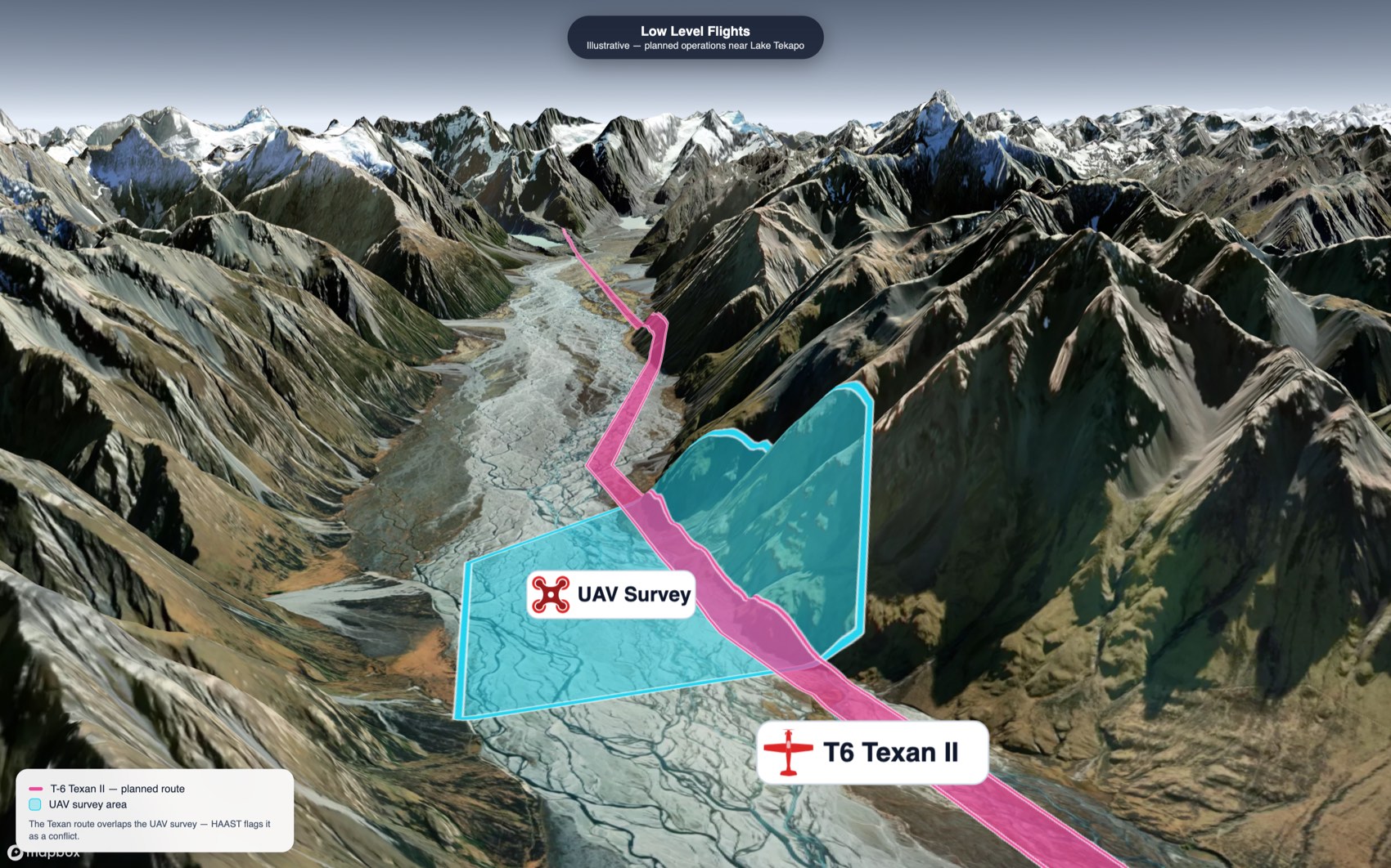
The Low Level flight environment can be busy in uncontrolled airspace - rotary, fixed wing and unmanned UAVs - Military and Civilian all share the same airspace. Draw your planned area, path or circle, set your altitude and operating window, and everyone else can see it and plan around you.
Draw an area, a route corridor or a circle — manned or UAV
Look up to 72 hours ahead with the time slider
HAAST checks for overlapping operations and warns you before you file
Obstacle Reporting
Report the Hazards the Charts Don't Show
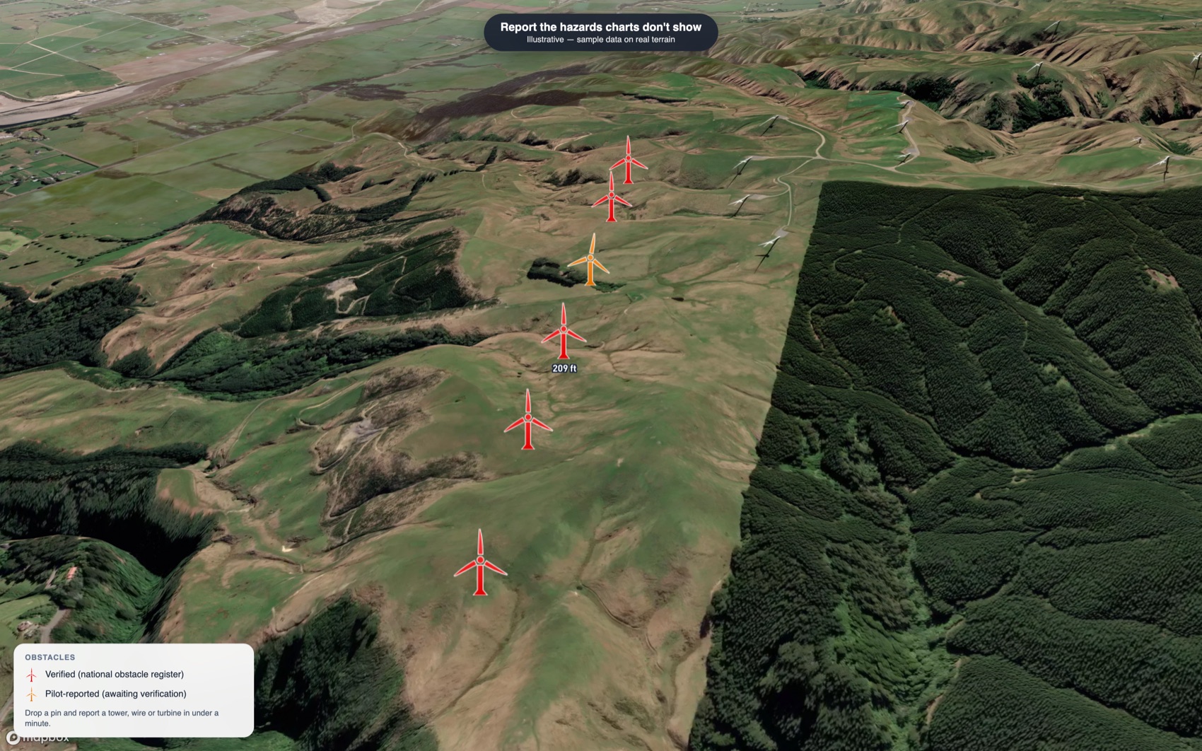
Wires strung across a gully, a new met mast, a wind farm — many low-level obstacles never meet the threshold to be charted, but they are still potential hazards to the operator flying around them. Drop a pin and report one in under a minute. It appears instantly for every pilot as pilot-reported, then moves to the national register once it's verified.
Towers, masts, antennas, wind turbines and wires
Shared with every operator the moment you report it
Pilot-reported markers, then verified into the national obstacle register


Administered by the Royal New Zealand Air Force
Where the RNZAF Notifies Low-Level Activity Across New Zealand.
HAAST is administered by the Royal New Zealand Air Force. It is where the RNZAF and wider Defence Force publish their low-level flying activity nationwide — so every other operator can see military operations and plan around them, just as Defence can see civilian intentions and hazards.
HAAST is open to all airspace users, free and voluntary.
About the Royal New Zealand Air Force
Features
Situational Awareness for the Low-Level Environment
Purpose-built for New Zealand operations outside controlled airspace — from survey and agricultural UAVs to helicopters and military training. Built for manned and unmanned operators alike.
File a flight intention
Draw your area, path or circle and file in minutes — manned or UAV, with your aircraft and operating window.
Automatic conflict detection
HAAST checks your intention against others in space and time and warns you before you submit.
Route briefing
A one-tap briefing of the airspace, obstacles, hazards and NOTAMs along your route, filtered to your altitude.
Watch-area alerts
Get notified by email or push when a new intention or obstacle appears in an area you care about.
Favourites & KML
Save and reload favourite intentions and import a planned route or area from KML — and electronic flight bag (EFB) integration APIs are available to EFB providers now.
2-D & 3-D terrain
Switch between aeronautical charts, satellite imagery and 3-D terrain to understand the vertical picture before you fly.
… and more. Log in to see how HAAST helps your operation.
Questions & answers
Frequently Asked Questions
What HAAST is, who it's for and how it fits alongside your other obligations.
HAAST (Hazard, Aerodrome & Airspace Safety Tool) is a free situational-awareness map for anyone operating in uncontrolled airspace. It shows planned low-level operations, reported obstacles and hazards, airspace and NOTAMs on satellite, aeronautical chart and 3-D terrain base maps — so you can build a picture of who and what is around before you fly.
Anyone operating in the low-level environment outside controlled airspace — agricultural and helicopter pilots, survey and general-aviation flights, UAV/RPAS (drone) operators, and the military. It is aimed at operations below roughly 3,000 ft AMSL or 1,000 ft AGL (whichever is higher), where charted information is thin and deconfliction is up to the operators themselves.
Low-level collision has been an increasing risk for NZDF aircraft. While originally the target audience for advisories was GA aircraft, in particular agricultural aircraft and helicopters, the increased use of unmanned systems in low-level airspace has increased exposure to all operators, both NZDF and GA, to the aviation risks they present. On any given day Defence aircraft train across New Zealand below 500 ft AGL at 210 kt or more, and the best way to reduce that risk is for as many operators as possible, both manned and unmanned, to share where they intend to fly and what hazards they know about. Keeping the barrier to entry low means the picture is as complete as it can be — which benefits everyone. HAAST is free and voluntary to use. It is administered by the Royal New Zealand Air Force and provided by Accredited Technology (ATEC) Ltd.
Registration is free — choose Free Registration, provide your details and upload a copy of your qualification — for example a pilot licence, Air Operator Certificate or UAV operator certificate. Every registration is reviewed by an NZDF administrator before the account is activated (normally within a week), and once approved you log in to open the map, file flight intentions, report obstacles and set up alerts. Your uploaded documents are used only for that check and are deleted once your registration has been actioned, or after 7 days at the latest.
NZDF aircrew file their low-level flights in HAAST, so Defence low-level activity across New Zealand is broadcast here consistently. Civilian operators can see it and plan around it, and Defence users can equally see civilian intentions and reported hazards. It is currently the single place low-level Defence activity is shared with other airspace users.
You can — nothing obliges an account holder to file. But HAAST only works if operators contribute. The Defence Force shares the system freely in the interests of combined safety on the understanding that operators use it in good faith and add to the picture by filing their own intentions and reporting the hazards they find. The more operators involved, the safer and more useful HAAST becomes for all of us.
No. HAAST is a situational-awareness aid only. It does not replace any regulatory notification, NOTAM, or airspace clearance process. Always meet your obligations under the Civil Aviation rules and treat HAAST as an extra layer of awareness.
Yes. A HAAST flight intention is not a flight plan and does not provide a search-and-rescue watch. It is up to each operator to decide how they maintain a SAR watch over their aircraft and to meet the flight-plan requirements of the Civil Aviation rules.
You can file a flight intention up to 72 hours ahead (24 hours for recreational UAV operators), and the time slider lets you scroll forward through the same 72-hour window to see what is planned. Low-level flying is heavily weather-dependent and rarely committed to further out, so the limit keeps the picture credible. Nothing needs cancelling: an intention simply drops off the map when its time expires, so you can file for just the low-level portion of a longer flight. You can edit or delete your own intention at any time before then.
No. HAAST shows what operators have filed, what Defence has published, reported obstacles and hazards, and low-level NOTAMs. There is no legal requirement for anyone to file an intention in HAAST, so treat the map as a strong indication of what is planned rather than a complete traffic picture. HAAST is not official aeronautical information.
Drone-specific planning tools are rarely seen by manned pilots. HAAST is where helicopter, agricultural, general-aviation and Defence operators publish their low-level intentions, so filing here is how you make your operation visible to them — how you get alerted when a manned flight overlaps yours — and how you can contact each other. HAAST is intended for UAV operations outside controlled airspace; it does not replace any authorisation required inside controlled airspace. You can upload pre-planned KMLs directly into HAAST and API integration is available.
Yes, both are required when you file, but you can switch on "Hide callsign and aircraft model" so other users see only your operating area and the general aircraft type. Hidden details remain visible to the NZDF and system administrators, and in the event of a conflict they are disclosed to the other party so the two of you can deconflict.
HAAST keeps the map focused on the low-level environment. Airspace is shown when its lower limit is at or below the low-level ceiling (3,000 ft AMSL), whatever its upper limit. Always check a full NOTAM briefing from an official source for your flight.
Flight intentions, reported obstacles and NOTAMs are live — changes appear for other users within seconds. Airspace, aerodromes and visual reporting points are maintained to the AIRAC cycle from the official NZ aeronautical registers. Base maps are drawn from Land Information New Zealand (topographic and terrain data) and Mapbox (satellite imagery) and update as those providers release new editions.
Log in, drop a pin on the map and complete a short form (tower, mast, wire, wind turbine and more). Your report is visible to every operator immediately as pilot-reported, then moves to the national obstacle register once it has been verified.
Once verified, reported obstacles feed the national obstacle register, which in turn feeds the annual VNC update. When an electronic flight bag picks up a new obstacle depends on how that provider refreshes its data, so check with your EFB supplier. In HAAST itself your report is on the map for everyone straight away.
HAAST has a Flight Intention API that lets electronic flight bags and planning tools file intentions and run conflict checks on a pilot's behalf, with the filing appearing in HAAST exactly as if it were entered here. EFB integration APIs are available now. Interested parties should contact Accredited Technology (ATEC) Ltd, the HAAST provider, to arrange access.
All data is encrypted in transit and at rest, and HAAST complies with the principles of the NZ Privacy Act 2020. The map is available only to logged-in, approved account holders — there is no anonymous public access. You can also choose to hide your contact details, callsign and aircraft model from other users. In the event of a conflict your phone number is shared with the other party so you can contact each other directly. Operational information you choose to file — such as a flight intention — is shared with other users so they can deconflict with you, while sensitive and agency-only information is access-controlled.
No. HAAST is designed to be the most comprehensive platform available for situational awareness of the low level environment, however it does not represent or replace official aeronautical information and you should seek official sources before conducting any flight.
About HAAST
Designed, Built and Supported in New Zealand
HAAST — Hazard, Airspace & Aerodrome Safety Tools — is a comprehensive aviation data platform, currently deployed across New Zealand. HAAST puts aviation data to work as a clear, interactive picture, built to give operators the situational awareness they need when planning low-level operations outside controlled airspace.
The platform supports a growing range of aviation data services.
Developed and operated by
The aviation division of Accredited Technology (ATEC) Ltd, a New Zealand technology company with a long track record building systems where accuracy and compliance are critical.
Matt spent 8.5 years leading New Zealand's Aeronautical Information Service, responsible under CAR Part 175 for the country's aeronautical data management, and the architect of much of the underlying data platform that powers it. He was the aeronautical information management subject matter expert for the CAA's New Southern Sky programme, has briefed the boards of numerous aviation organisations and has represented New Zealand in this field at ICAO. His work on aviation safety tools has been recognised internationally.
Questions or feedback? Send it through via the feedback section within HAAST, or get in touch.
Get started
Log In to Open the Map
Review planned low level flights and obstacles, file your own flight intentions, report obstacles and set up watch area alerts — free with an approved account. Don't have one yet? Registration is free — use the button below.
Get in Touch
HAAST@nzdf.mil.nz
Hazard, Airspace & Aerodrome Safety Tools · Aotearoa New Zealand
Administered by the Royal New Zealand Air Force · Provided by Accredited Technology (ATEC) Ltd
© 2026 Accredited Technology (ATEC) Ltd. HAAST is a situational-awareness aid and does not replace regulatory notification or airspace clearance processes.